Midway
Como
Frogtown
Como
Frogtown

News for everyone, delivered to everyone
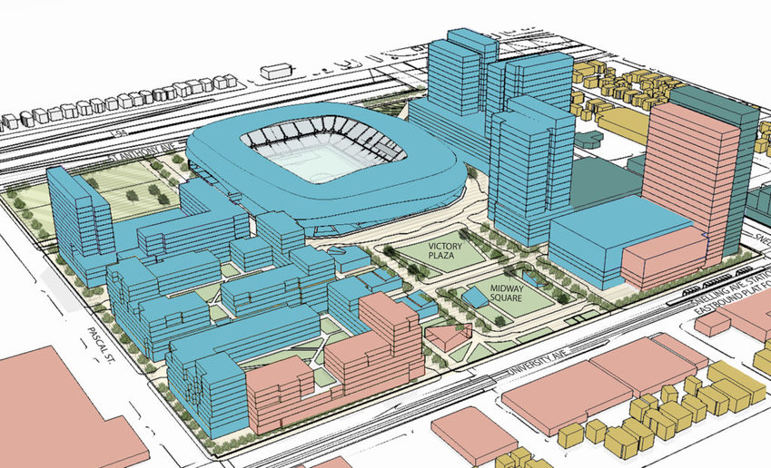 The Snelling Station Area 2030: This model illustrates one possible long term scenario for meeting these community, place-making and transit-supportive opportunities. It principally describes a vision for the Snelling Station Area as a vital hub of commercial activity along the corridor with an expanded street and block system; an enhanced public realm network and active main streets. Rather than attempting to predict the location and distribution of anticipated long-term investment, this conceptual model illustrates the application of transit-supportive principles throughout the entire Station Area. The total development yield illustrated is therefore not meant to be representative of the 2030 market forecast (Figure 2.2) for this Station Area, but demonstrates one possible example of transit-supportive developments for each individual parcel. (Illustration from the Update Draft of the Snelling Station Area Plan)
By JANE MCCLURE
A decade ago, many area residents and business owners made regular trips to the former Lexington Outreach Library at 1080 University Ave. to work on plans for Green Line station areas. They gathered around maps and scale models, armed with sticky notes and ideas. Now those plans are changing at the Snelling and Westgate areas, to focus on how parks and open space have changed in response to recent development.
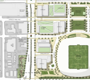 Illustration right: The Boulevard will transform Snelling Ave. with wider sidewalks, street trees and active ground floor uses such as shops, cafés, and office building lobbies at street level. (Illustration from the Update Draft of the Snelling Station Area Plan)
The station area plan for Snelling is one of two soccer stadium-related changes the Planning Commission has been working on. The commission approved sign ordinance changes June 29 and sent them on to the City Council for a final public hearing this summer, to allow more advertising signs at Allianz Field and at the new Treasure Island ice arena downtown.
The other change, to “public realm” for Snelling and Westgate station area plans, will be the focus of a public hearing at 8:30am, Fri., July 27 at City Hall.
City Planner Anton Jerve said the changes reflect redevelopment in both areas. Since the station area plans were adopted almost a decade ago, much has changed, he noted. That’s especially true at Snelling and University, where an ambitious new master plan to redevelop the Midway Center superblock won City Council approval two years ago.
Westgate Dominium Development’s plans for senior and workforce housing on the former Weyerhaeuser lumber yard site include trails and park space, which will be reflected in the new plan.
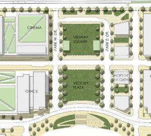 Illustration left: The large public open spaces Midway Square and Victory Plaza between University Ave. and Allianz Field stadium are planned for activities that range from passive recreation to festivals, farmers markets, and food trucks. (Illustration from the Update Draft of the Snelling Station Area Plan)
At Snelling, the stadium development plans call for two large green spaces between the stadium and University Ave., Victory Plaza and Midway Square, as well as smaller green spaces along St. Anthony. A United Champion Plaza is planned at the northeast corner of Snelling and St. Anthony avenues.
What was envisioned as the Snelling Transit Plaza at the southeast corner of Snelling and University avenues is now labeled “the boulevard.” One line of the plan revisions states “The boulevard will transform Snelling Ave. with wider sidewalks, street trees and active ground floor uses such as shops, cafés, and office building lobbies at street level.”
Other changes reflect alterations in the street grid in both station area plans, and elimination of references to groups that no longer exist, such as the Central Corridor Funders Collaborative.


Comments
No comments on this item Please log in to comment by clicking here